Wednesday, September 13, 2006

Another Namadgi Trail


Yerrabi Trail

According to the trail guide the word "Yerrabi", means "walk" in the Aboriginal language. This trail takes you past a more wooded area of Namadgi, to a trig point. The area around the Yerrabi trail seems to have been be untouched by the 2003 bushfires which caused substantial destructon to the Northern parts of the park.

How to get there
From Tharwa, drive along the Nas road continuing past the point where it splits into Boboyang road. Past this juncture the Nas road is unsealed. You need to take the right fork which will place you on Boboyang road. Follow the road some time after it too, becomes unsealed and continue past the look out, until you arrive at the Boboyang Trig carpark. Be sure to stop at the look out on the way as the view from there is quite spectacular. See picture 1.

The walk
The walk commences with a gentle descent up until the point where the trail cuts across an area of swampy grassland and passes across Little Dry Creek. As you walk up the slope towards the trig point you notice a subtle change in the trees, with the occassional Snow and Mountain Gum becoming more frequent. The trees in the lower reaches of the walk are mainly peppermint gums. The Boboyang trig is at an elevation of 1459 metres. The view to the north east is the best panoramic aspect. However, the view from the Trig is not as good as what you can see from the lookout. The panaramic pictures I took show rain falling on the nearby mountains.


The walk took about an hour and ten minutes, but it's rated a two hour walk of moderate difficulty. Despite the ascent the Yerrabi Trail is a relatively easy walk of about 4 and a half kilometres return.


Pictures: 1. View from the lookout on the way to the Yerrabi trail. 2 View from the trig. 3. Ascent to the Trig. Click picture to see enlarged image.


Tuesday, September 12, 2006

More of Namadgi


Yankee Hat Trail

Last weekend I did two walks. The Yerrabi Track and the Yankee Hat Trail. The latter provided an opportunity to see some ancient rock art. Both walks were in Namadgi National Park which is 40 km south of Canberra. The park, which takes its name from the Ngunnawal word for the surrounding mountains, was created in 1984.

How to get there
Drive to Tharwa and then continue along the Nas Road. A short distance past the point where the Apollo Road runs into Nas Road, it splits into Boboyan Road to the right and the continuation of Nas road on the left. This is unsealed and leads to a canola farm. Take the right fork you’ll be on Boboyan Road. Continue past Orroral road until you reach the turn off to the old Boboyan road. This is an unsealed road that leads directly to car park where the trail begins.


The walk
The early part of the trail passrs through a cleared area with marshlands surrounding Bagong creek. This area was cleared by pastoralists, creating the grass plains which sustain the many grey eastern kangaroos to be seen in the area near the marsh land.

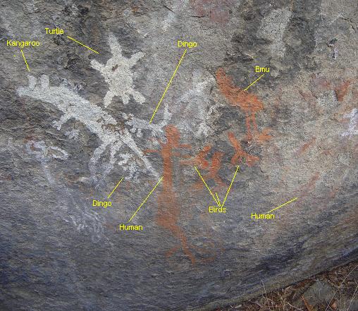
The three kilometre walk to the foot of the Yankee Hut Mountain takes you to a strange rock shelter. Carbon dating of campsite deposits suggests that the area was first used about 800 years ago. The style of the artwork in the shelter is characteristic of the people who inhabited the southern tablelands of NSW. In the photo below some of the figures are orange. These are the newest paintings, with the oldest and most difficult to discern being dark brown. Other campsites in the surrounding area have been dated back to 1700 bc.

The scenery is striking, the wildlife abundant and the aboriginal art, a real treat. The six kilometre walk to the shelter took about an hour and twenty minutes even though it's rated a two and a half hour walk. Overall the trail is an extremely engaging and very easy walk. However, its too short. It would be good if it was extended to the top of Yankee Hat Mountain.


Pictures

1. Panorama, 2.Bogong creek and Marshlands, 3.Eastern Grey Kangaroos, 4.rock art and 5.Yankee Hat Shelter.


Monday, August 28, 2006

Brisbane Ranges National Park

BRISBANE RANGES NATIONAL PARK

How to get there
I
had trouble locating the park entry using my TomTom GO. It didn’t even recognize “Balliang” so I had to resort to my trusty Melways. The park is around 60 km west of Melbourne via the Princes Highway towards Geelong (Melway Ref: 511 D3). Turn off at Werribee and then follow the Ballan-Geelong Road. An alternative way there, is to travel via the Western Freeway to Bacchus Marsh and follow the Geelong-Ballang Road, turning off to Boar Gully, Balliang or Anakie. I didn’t take the latter route. However, I think it’s the quickest way there from Melbourne.

Walk undertaken

This was my first visit to the park. I did the Slater Trail down to the footbridge and part of the Quarry trail. This wasn't exactly a highlight walk, but it was a good introduction to the park. I intend to visit again.

Main attractions
A feature of the park is the abundance and variety of flora. According to the visitor's guide there are some 619 native plant species (about one fifth of Victoria’s total) in the Brisbane Ranges.

For example, "Brisbane Ranges Grevillea, is only found along the Rowsley Fault; Velvet Daisy-bush is rare and found only in scattered locations across the state; Golden Grevillea is found elsewhere only in Gippsland.”

In spring there is a magnificent display of wattles, hakeas and bush peas. A variety of orchids can also be found throughout the area. The wildflowers were already starting to bloom at the time of my visit in August and there should be a good show in the next few weeks.

Brisbane Ranges Nat Park 024

Brisbane Ranges Nat Park 026


An illustrated guide to the wildflowers of the park has recently been produced by the Friends of Brisbane Ranges National Park. This can be accessed at:


http://home.vicnet.net.au/~fobr/plantlist.pdf

History of the Park
The Wathaurong Aboriginal tribe occupied the area around Geelong and small clans regularly occupied the Brisbane Ranges. To put it in the most diplomatic way possible, the indigenous population declined seriously following the uptake of pastoral runs around the Brisbane Ranges by squatters around the time Melbourne was founded. Most grazing was centred on richer lands along the Moorabool River to the east of the Ranges.

Gold was found in the Anakie hills in 1851 and miners began arriving soon after. This also had a deleterious impact on the native peoples. In 1855 many gold reefs were found near what became the town of Steiglitz. By 1862 there were over 600 miners in the area. The town’s fortunes slumped between 1876 and 1890, revived briefly until the early 1900s and then declined to the present ghost town status.

The gold years had a considerable impact on the ranges, as much of the forest was cut to provide mine props, building timber and firewood. One can see evidence of diggings throughout the Park.

The park was established in 1973. It comprises an area of some 77.18 km² and is located near the town of Meredith.

Birds and other wildlife

Among the mammals of the ranges are eastern grey kangaroos, wallabies, echidnas, possums and gliders. The small number of koalas has been increased over the years with stock from Phillip and French Islands in 1957 and 1977. They are reputedly common in the park and a research grid has been established by the Friends of the Brisbane Ranges to monitor their numbers. Unfortunately I didn't see any on my visit. The ranges were severely damaged by bushfire in January 2006 and some walks such as the Anakie Gorge walk are closed.

On my walk, I disturbed three eastern grey kangaroos near the junction of the Quarry Trail and the Slater Trail. They took off too quickly for me to take a photo.

Over 170 species of native birds have been recorded in the park. Three species of particular note are the Yellow-tufted Honeyeater, White-throated Nightjar and Rainbow Bee-eater. Bird lists are available from the Anakie Information office .

Brisbane Ranges Nat Park 042

Challenges

A serious problem in the park is the presence of Cinnamon Fungus. This organism invades the fine roots of many native plant species, causing root rot. Infected plants have difficulty absorbing enough water through their remaining roots, particularly in summer and may die. There is no cure for the disease and several trails are closed in an attempt contain the spread of the disease by preventing the movement of infected soil.

I also noticed that several parts of the park appeared to have been burnt out by bushfire. l quite like this park. There's a large number of walks to do and it's proximity to Melbourne means you can do half day walks. Allow one hour driving there, an hour back and three hours walking. Perfect.


I'm sorry I'd not visited it earlier. I will put up an update of the park after my next visit sometime in September.
Brisbane_merged 4


Monday, May 22, 2006

Trip two to Namadgi


Trip two to Namadgi

Today I drove to Namadgi for a quick walk to Smoker’s Flat and Square Rock. The walk to Square Rock was an easy one and took me between two and three hours…It was gradual ascent but one that was ultimately very rewarding …the view from Square Rock is magnificent and about 600 metres before you arrive there’s a lookout that’s almost as spectacular. (see photo one). This is a good walk as which anyone can manage. There’s a small ladder climb once you arrive at the rocks. If you go up with kids you'll need to watch them around the top asthere is a sheer drop.

In places the rocks hover ominously over a sheer 80 metre cliff face and you feel uneasy moving around the top, but it’s a splendid place. I had a brief meal at Square Rock before returning…On the drive home only twenty kilometres from Tharwa, I saw dozens of kangaroos and about 30 galahs. The only animal I spotted on the walk was a wombat. Unfortunately, I couldn’t manage a photo in time.

I plan to do another trip to Namagdi in a few weeks and walk to Coronet Peak along the track that connects to Kosciuszko National Park. Click on the Photos to see enlargements.


Sunday, January 29, 2006

Namadgi National Park, Australian Capital Territory

View from Booroombra towards Tuggeranong
Pictured above is a view from Booroombra Rocks. This shows 6 images pasted together using photostitch.

Walking through Namadgi National Park one can see evidence of both sandstone and granite formations. The oldest exposed rocks in the Namadgi park area are sedimentary sandstone, mudstone and shale. These were deposited between 470 and 440 million years ago during the Ordovician Period. In some of the rock formations here, the remains of small marine animals called graptolites have been found. These remnants indicate that the sediments were deposited in fairly deep seawater. At that time most of southeastern Australia was underwater. Forgive my ignorance but I'm not sure whether it would have been part of the Tasman or the Atlantic. Even though Namadgi is close to Canberra and is, in fact, the only National Park I'd visited in the ACT, it's taken me some time to get to there. Perhaps that's because I simply cannot equate a good time with remaining in the ACT. Perhaps in part, it's because the 2003 bushfires which devastated much of the park lead me to expect some fairly drab scenery and reduced its appeal. I guess I was curious about the countryside and I was interested in seeing how much damage had been done to the park. Fire is a natural occurance in the park but the severity and damage caused by the 2003 bushfires was without precedent. The areas comprising Namadgi NP collectively amount to 106,000 hectares and make up almost 45% of the land area of the Australian Capital Territory.

Now that the growth of Canberra has pushed the population to 335,000 people, the park is destined to be an environmental flashpoint around water and land use. In fact, I saw plenty of placards in the park (or perhaps private land) protesting the dam proposed for the Naas river. The human intrusion is evident when one considers the proximity to to new housing in the Tuggeranong valley.

How to get there
Take the Monongo highway to Tharwa and then turn into the Nas Road. Drive a little while past Tharwa and you'll come to the Namadgi National Park visitor centre. The park is large and has many points of interest. I drove to the Northern part of Namadgi and did the short walk to Baroombra Rocks followed by a 12 kilometre walk along the Old Boboyan Road. All of the photos are of the Baroomba Rocks walk.
DSC03405
Above: New gowth amongst the remains of a dead firedamaged tree

Geologicial History
Having been underwater for most of the Silurian period, towards the close of the Silurian period approximately 400 million years ago, the area was intruded by a huge body of granite known as the Murrumbidgee Batholith. The many fantastic granite boulder formations that are to be found in the park resulted from this intrusion. There were major earth movements throughout the whole of southeastern Australia between 400 and 350 million years ago. Rocks were folded and raised into high mountains by tectonic forces. A walk along the Yerrabi Track in the southern end of the park reveals two distinctive geological zones that meet near the Boboyan Trig. The eastern approach to the trig consists of sedimentary rock laid down when the area was under the sea. To the west is granite that intruded into the sedimentary rock. The sedimentary rock overlaying the granite has now worn away, exposing the weathered boulders seen today.

Namadgi has a rich heritage of human history. A rockshelter at Birrigai, just north of Namadgi National Park, contains evidence that Aboriginal people were living in the region during the last ice age 21 000 years ago. That’s actually in the Tidbindilla nature reserve. Clues into the lifestyle of the local indigenous people are found throughout the park. These include quarry sites where stone was gathered for tool making, campsites with discarded fragments of stone and animal bone, ceremonial stone arrangements on the high peaks, and rock painting sites. Other information comes from the journals of 19th century European settlers written in the brief period before the Aboriginal people were decimated by introduced diseases, and dislocation from their lands.

The first pastoralists settled in the broad valleys at the southern end of the park in the 1830's. They faced a struggle to establish themselves in a remote area subject to severe weather. Today the story of their efforts is told by the fences, yards and homesteads that remain. In the 1860's fortune seekers travelled the Kiandra gold trail from Tharwa to Yaouk. Parts of the trail are still visible in the Gudgenby area. Space tracking stations operated from the early 1960's to the early 1980's at Honeysuckle Creek and in the Orroral Valley. They were instrumental in monitoring the Apollo program. Honeysuckle Creek was the first place on earth to receive the images of Neil Armstrong, the first man to walk on the moon. Today the site is abandoned.

Flora
Namdgi has a wide range of plants, many of which are found only in Australia's alpine and sub-alpine environment. Even along a short walk, vegetation and wildlife can change dramatically, particularly with increasing elevation or a change in aspect.

Woodlands
Low open woodland covers most of the park, although a great portion were damaged in 2003.
Broad-leaved peppermints, as seen along the Boboyan Road, dominate the lower altitudes whereas snow gum woodland, as seen along the Mt Franklin Road, is found at higher altitudes. Wet forests occur in the sheltered locations, especially on the western side of the park. Stands of ribbon gum follow watercourses; alpine ash grow on suitable south-facing slopes; and brown barrel eucalypts tower above tree-fern gullies.

Namadi_six
Above : Another view from Booroombra Rocks

Large open grasslands occur on the eastern side of the park such as the Orroral and Boboyan valleys. These grasslands were extended by graziers last century and sown with introduced grasses. They remain treeless due to the cold air that drains off the hills at night; frequent frosts make it difficult for trees to re-establish. It was diffficult to gain insight into what the park was like, as the areas I visited had sustained heavy damage from the 2003 bush fires. There was substantial evidence of fire damage and regrowth in the areas I walked through, the grasslands as one would expect are quite resilient and show no evidence of bushfire.

Below: Dead Trees and regrowth
DSC03390

Fauna
Namadgi provides a habitat for a wide range of native fauna. Over 222 species of vertebrate fauna have been recorded to date with several threatened and rare or uncommon species. For example the broad-tooth rat Mastacomys fuscus, northern corroboree frog Pseudophryne pengilleyi and river blackfish Gadopsis marmoratus. The northern corroboree frogs live exclusively in the subalpine areas of Namadgi and adjacent parts of NSW. They are currently under threat of extinction. I didn’t see any animals on this walk. Just a few skinks and there was an absolute plague of Mountain grasshoppers. I did spot a group of gang gang cockatoos.

This was my first visit to the park. All in all, it's been a good experience.

Saturday, January 14, 2006

Kinglake National Park

Kinglake National Park is the largest of the national parks within a 100 kilometre radius of Melbourne, with 216,000 hectares of rolling, forested hills and fern gullies. The park is notable for its tall forests, fern gullies and population lyrebirds. The park is located on the Great Dividing Range some 65 kilometres north east of Melbourne.

How to get there?
There are three main routes. I drove there via the Heidelberg - St. Andrews Road from St. Andrews. It’s a slow route because the road is windy and rather narrow, but it gives you time to admire the scenery.

The park consists of four separate blocks of forest that are physically separated from each other by freehold land (mostly pastoral and residential holdings). These are the Sugarloaf block to the west, the Everard Block to the south-east, the Wombelano Block to the north, and Wallaby Creek Designated Water Supply Catchment area to the far west.

The basal rocks of the Kinglake area are sedimentary mudstone and sandstone that formed on the bed of an ancient sea. Around 440 million years ago, the Kinglake area lay under a shallow sea in the “Melbourne trough”. At this time the only animal life consisted of marine creatures such as trilobites, echinoderms, sea sponges and graptolites. Primitive land plants had only just evolved.

The very warm, wet climate meant that there was massive erosion of mud and sand from surrounding areas into the Melbourne trough, trapping many of these marine animals which now appear as fossils in the mudstone. This process continued for about 50 million years resulting in a layer of mudstone over 1000 metres thick, 45 metres of which is exposed at Masons Falls which are pictured below.

Kinglake National Park has three main types of vegetation, although there are many variations of these main vegetation communities. The plateau supports tall, wet eucalypt forests. The eroded ridges support dry eucalypt woodland. Between the ridges in the deep gullies are found lush ferns and mosses along with a host of wet gully plants. Aspect, soil types and climatic variations determine these different vegetation types in the park.


The open forest on the plateau country is dominated by Narrow-leaved Peppermint and Messmate Stringybark. It has layr of mostly shrubs such as Common Heath, Hop Goodenia and many different types of native peas. Hazel Pomaderris, Wonga Vine and Forest Clematis occur in some wet gullies.

In the gullies, Mountain Grey Gum and Manna Gum are the main trees, but in some sheltered sites in the east, pockets of Mountain Ash are found. The understorey typically includes Blackwood, Silver Wattle, Hazel Pomaderris, Blanket-leaf, Musk Daisy-bush, with a dense understorey of treeferns - Soft Treefern is found in the base of the gully while Rough Treefern occurs a little higher up.

In some gullies where drainage is impeded, Swamp Gums form an open forest. The understorey here is often dense. A small pocket of this vegetation type occurs on the other side of the road from Island Creek Picnic Area. These plants require ricer soils and the wash of water from higher areas generally sweeps down richer sediments and nutrients.

The vegetation types conserved in Kinglake National Park are typical of those that once occurred over much of the foothills and southern slopes of the Great Divide in Central Victoria. Of course these were cleared by squaters and pastoralists long ago.

There are said to be 36 native species have been recorded in the park. They include the Eastern Grey Kangaroo, Swamp Wallaby, Brush-tailed Possum, Common Ring-tailed Possum, Feathertail Glider, Sugar Glider, Greater Glider, Yellow-bellied Glider, Common Wombat, Long-nosed Bandicoot, Brown Antechinus, Dusky Antechinus, White-footed Dunnart, Swamp Rat, Water Rat, Short-beaked Echidna, Platypus, and a number of bats. Several hundred koalas were reintroduced into the park in the 1970s after having been almost totally wiped out during bushfires in 1926 and 1939.

There are also said to be introduced species such as feral cats, pigs, black rats and common house mice. I saw a wombat and an echidna and various parakeets on the day I visited .

Pic 1 Matt Checking out tree
Matthew at KLNP  merged 2

Pic 2 Bush panorama
Typical Woodland scene

Pic 3 Hiking through the bush
Mason Falls

Pic 4 Daniel with echidna
Daniel with Echidna

Pic 5 Thin woodland
Typical woodland

Wednesday, December 21, 2005

Kruger National Park, Mpumalanga and Limpopo, South Africa

Although “Kruger” is one of the world’s premier wildlife parks, populated by thousands of elephants, and just about every other animal found in Africa, somehow the name seems distinctly unAfrican. It almost conjures a picture a huge bruiser with biceps large enough to punch me into next year.

Yet, the park, which is over a hundred years old, takes its name from Paul Kruger, who issued a proclamation establishing it in 1898. At first, it was much smaller and consisteted of the Sabi Game Reserve, a 4,700 square kilometre cross-section, delineated by the Sabie and Crocodile rivers.


Since foundation the park has grown steadilty, combining a number of adjacent reserves. There's a granite memorial with a bust of Paul Kruger in the park.

More information can be obtained on
http://www.krugerpark.co.za/ and also at the official site http://www.sanparks.org/ which has everything you need, ranging from distance tables to maps and trails and various amenities. The South Africans represent best practice in provision of information to park users. In fact, they put our national wildlife websites to shame. Check out http://www.sanparks.org/ and compare this with the pathetic NSW wildlife site at http://www.nationalparks.nsw.gov.au/

The SA sites give you everything, even waypoint coordinates. For example, 31.80064 -23.9963 are the coordinates for the Satara Camp which I stayed at. Try getting that or even a trail map from the NSW sites.

How to get there

Drive along the N4 from Joberg, passing through Witbank, all the way to Nelspruit and finally to Komatipoort about 490 kilometres away. That will place you at the southern most gate of Kruger National Park, the Crocodile bridge gate. More detailed directions on how to get to each gate appear on the above listed websites. Once you're at Nelspruit the way to Kruger are well sign-posted.


I told my kids that I had to get up so early in the hope of spotting a big cat, that the mules where still in pygamas.


Blue Wildebeest (above)


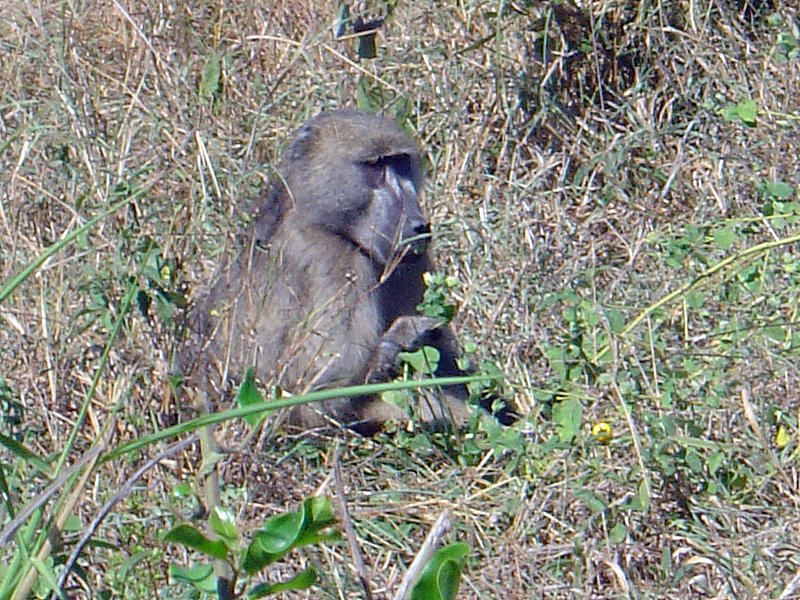
Baboon (above)

Ten minutes after entering the park in an area not normally known for elehants, I run into this guy (see below.) Most of the elephants are in the middle of Kruger, around the Oliphants river.

As I said above, I'd entered at the crocodile bridge gate and came out a couple of days later near the top, emerging from the Punda Maria Gate (in Limpopo) and heading back to Johannesburg via Polokwane (or Peterburg). While there I stayed at the Oliphants and the Satara camps.

The facilities at Oliphants and, generally throughout the park, are excellent. Each of the camps is walled and, is in effect, a small town with all the creature comforts of home. I saw plenty of elephants, hippos, rhinos, but no big cats. To see them you need to go on one of the game drives.

The Oliphants camp takes its name from the Oliphants river. The Camp directly overlooks the Oliphants river which is around 100 metres above it to the east. The accommodation at Oliphants is reasonably new too. There is a viewing area just under the restaurant where you can see up to dozen of elephants congregate in the water below. In fact, the area surrounding the camp is full of them.

Anyway, I had a fantastic time. Ciao to Isabella who I met at Satara.

(Love is in the air, below)

Enjoy the photos.(Click em to enlarge em).

Tuesday, December 20, 2005


My Old Muddy Boots

I’m a man with no roots,
I am he, who faithfully wears these muddy old boots

How can I let you go
when you’ve carried me atop Kosciusko
and in the winter bleak,
all over Mount Stirling’s frosty peak,
heel compressing the snow.
It seems cruel to now toss you out so.

Together we've explored the majestic Drakensburg,
and in Mosi-O-Tanya, surveyed the savage herd.
In Vietnam, you’ve carried me through Ho Chi Minh’s chaos
and across the serene foothills of luscious Laos,
through the streets of Hoi An
and the throng of Da Nang,

Foot in boot, we’ve kicked aside the stones of the Kalahari,
and we have gone for a stroll in downtown Nairobi.
In Masvingo, we meandered about in the ruins of Great Zimbabwe,
and how you squeaked on the dark volcanic sands of Bali
Oh my boots so old and so dear,
do you remember when I christened you with beer
to bless my trip to Zanzibar
or as I set a course to a new different star.

And while you’re ten years old
and the damp and cold
now creep into my toes
there’s no way I’m saying “out youse goes”,
to the dear old muddy boots
of this man with no roots.


Thursday, December 15, 2005

Golden Gate Highlands National Park, Free State, South Africa


I'm not sure quite how I got there, but I believe I drove along the N6, coming down from Gauteng to the Free State. It was an easy three hour drive from Johannesburg. As usual I abused my company car and hammered the Jetta. From the Free State it's possible to do a round trip of the highlands, taking in Lesotho as well. Unfortunately, I find it impossible to be that organised. I need to marry an organised woman. I'm sure that I passed through Villiers, Harrismith, and Clarens. My speciality is in finding my way out of the shit when I'm lost. That's a skill you need to acquire if like me you're the sort of guy who could lose a button in matchbox.

Or then again maybe I didn't go down the N6. The route I took skirted the mountainous eastern flank of the Free State. This region is the conservative heartland of Afrikanerdom, and it lies landlocked in the centre of South Africa. I traveled through the Free State a few times while I was working in South Africa in 2004.


Southeast of the Golden Gate Highlands National Park, you can drive to the Sentinel car park passing through the hike up to the highest plateaus of the Drakensberg - easier than starting from a much lower altitude in the Royal National Park. Clarens is by far the most attractive of the string of towns running along the Lesotho border. I stopped there to get something to eat on my first trip to the Free State. Clarens is full of arts and crafts shops and those artsy fartsy cafes that attract a well-heeled and cultured crowd.


Sadly I didn't have enough time to explore the Qwa Qwa National Park or the nearby Bashoto cultural village. Even worse, I had left my camera back in my car and didn't take any photos of the Golden Gateway Highlands National Park. The photos here where taken during my first trip with a friend, Johan Smith.

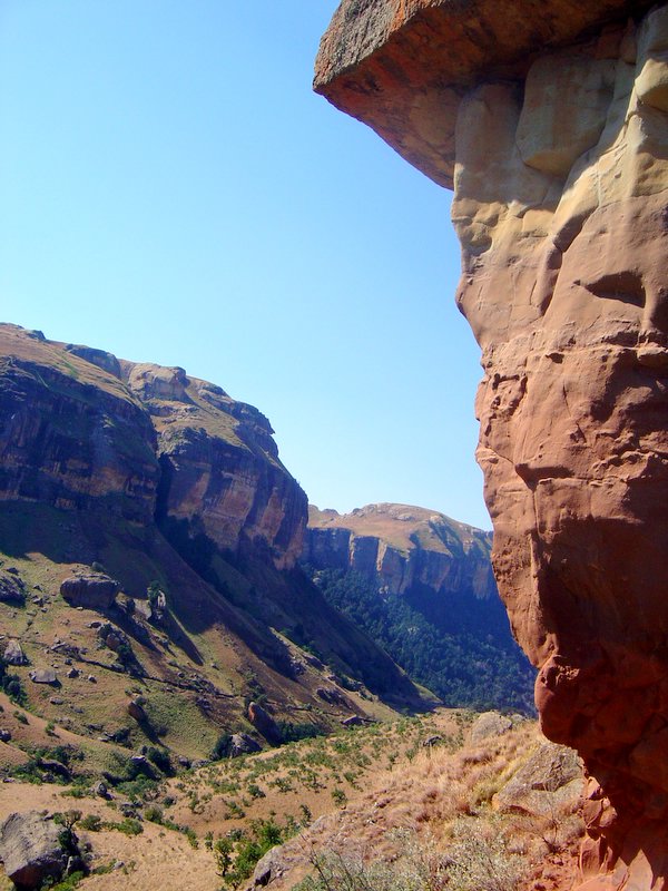
Anyone who has driven through the area will realise that the highlight of the Eastern Highlands is the Golden Gate National Park. This park is special not for its wildlife, but due to the spectacular Maluti Mountains with their stark red sandstone outcrops.

Enjoy the pictures. Click em to enlarge em. 1 Free State Panaroma 2. More Free State Vistas 3. Titanic Rock. 4. Me and my lovely Jetta. 5. Jetta abuse.

Monday, December 12, 2005

Chobe National park, Botswana


How to get there. Basically I drove from Johannesburg to Gaborone, the Capital of Botswana and caught an Air Botswana flight to Kasane about 5 kilometres from Chobe National Park.

Chobe is the second largest national park in Botswana and covers 10,566 square km. It takes its name from the Chobe river. Chobe has one of the greatest concentrations of game found on the African continent. Its uniqueness in the abundance of wildlife and the true African nature of the region, offers a safari experience of a lifetime.


The park is divided into four distinctly different eco systems: Serondela with its lush plains and dense forests in the Chobe River area in the extreme north-east; the
Savuti Marsh in the west; the Linyanti Swamps in the north-west the hot dry hinterland in between.A major feature of Chobe National Park is its elephant population currently estimated at around 120,000. Jesus! That's three times as many elephants as in all of South Africa. No wonder there's hardly any living trees in the place. Elephants are very destructive and tend to push over small trees to better reach to leaves. The Chobe elephants are migratory, making seasonal movements of up to 200 km from the Chobe and Linyanti rivers, where they concentrate in the dry season, to the pans in the southeast of the park, to which they disperse in the rains. As Chobe has no fence around it, the animals, including the lions, can roam about freely. I hired a 4WD to visit the northern section some 55 kilometres from Kasane and the Avis rep told me that two months ago there were lions just outside the loby of the Chobe Marine Lodge. One frequently sees elephants outside the park.


Chobe is often described as one of, if not the best, wildlife-viewing area in Africa today. It has of the highest concentrations of wildlife left on the African continent. Animals are present during all seasons, and at certain times of the year their numbers can be staggering. Especially the numbers of elephants. If you allow yourself adequate time here (a minimum of three to four days is recommended, I was there for five days) you will probably see nearly all the major species: giraffe, elephant, zebra, impala, tsessebe, roan, sable, wildebeest, kudu, buffalo, waterbuck, warthog, eland and accompanying predators including lion, hyena, jackal, bat-eared fox and possibly even cheetah and wild dog. I saw all but cheetah and leopards. There are plenty of hippo vultures and crocks. Savuti is famous for its predators, particularly its resident lions and spotted hyena populations. Mosquitoes are prevalent throughout the park and you need to take
anti-malarials and use generous quantities of insect repellent.


It's hard the do Chobe justice. It's beautiful and the wildlife is abundant. In many parks its hard to see elephants, but in Chobe there are so many that you literally must try to stay out of their way. Chobe comprises four main areas: the Chobe river frontage, the central pans around Nogatsaa, the Linyanti wetlands and the famous Savuti region that includes the Mababe Depression.

I did the river front by ferry and safari and I hired a 4WD and did the the Savuti.


Pictures:
1. Chobe elephants. 2. Wild dogs 3. Elephant
Elephant carcass, Chobe river front, 4 Zebras on the Savati,
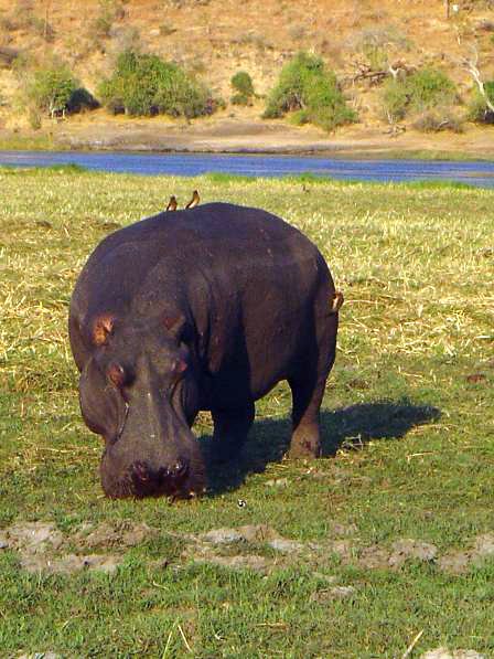
5. Some type of African Tree (not very informed of me) 6. Calf suckling, 7. Hippo on Chobe river, 8. Giraffe (Savati). 9 Crocodile in the Chobe River
The Drakensberg, Kwa-Zulu Natal, South Africa

The majestic Drakensberg is South Africa's most impressive mountain range. At it's highest points it exceeds 3 000 metres. The Zulus call the Drakensberg, "Ukhahlamba" or" the wall of spears". In Afrikaans it means, "the home of the dragon". The Mountains provide a magnificent semi-circular border between KwaZulu-Natal and the mountain kingdom of Lesotho. Most of the villagers living around the Drakensberg are not Zulus but are Sotho.

The basalt peaks divide the rains and snows, some flowing westwards over the alpine plateau of Lesotho towards the Atlantic Ocean, and some down the frequently vertical slopes into KwaZulu-Natal, towards the Indian Ocean. The Drakensberg range is the source of the Tugela River, the largest river in the KZN, and it plunges some 2 000 metres over the edge of the Mont-aux-Sources Plateau in a spectacular waterfall. This waterfall, called Tugela Falls, is the second highest waterfall in the world.

Most of the Drakensberg falls within the Natal Drakensberg Park, a wilderness area with an abundance of wildlife. In the three days I spent walking there, I walked within 10 metres of bushbuck, mountain reedbuck, and baboons. Overhead, as I walked I could see enormous bearded vultures. I went in July and the weather was warm. There are no predators in the park so it's safe to walk through it.


My first day was in the northern berg in the vicinity of the Giant's Castle. It may have been the Singati Valley.

I took my GPS device, which is a Garmin e-trek vista. It came in handy. I decided to leave the trail and head up to the top of the plateau. I then walked to the Lesotho border and back. Unfortunate I didn't take enough water and a got into some difficulty. I was expecting the climate to be cooler than it was. I had just two 500 ml bottles and one ruptured. On the day I went it was extremely hot. I easily found my way back to the starting point but I couldn't get down from the plateau. I found the decsent would shift from a steep 45 degree decline into a sheer vertical drop necessitating a back track up to the plateau. After an hour and a half of doing this without a drink, I decided to walk back to the original point where I left the trail. Luckily I had taken a waypoint there. I was getting nowhere going back and forth like this. It was like being on a stepping machine at the gym for ninety minutes. Making that decision was depressing because I had backtrack and extend my walk by about three hours and I was in such a distressed state that I started to lose my peripheral vision. But there was clearly no way down.

My feet were really aching and felt like mush. When I finally got back to my car I slumped into the seat and sat there exhausted. I waited as long as I could, trying to muster the energy to drive to the visitor centre. At about ten to five I realized that the visitor centre was about to close so I drove there and bought some water, beer and an ice cream. I skulled a litre of water in about ten seconds flat and then I started on the ice cream. I couldn't even remember eating it, I just remember taking off the wrapper and then shortly after holding the wooden stick in my fingers.
Funny thing is that after I consumed the ice cream I felt a lot more energetic. But it was probably the water. My face looked like I had powdered it with flower and it was white from the salt streaks. I drove back home to "Little Switzerland" with my beer and spent the night recuperating. When I took my boots off my feet were't in bad shape at all. I didn't have any blisters but three of my toe nails were coming off.

I reflected on my many stupid mistakes. Mistakes I would never have made if I were hiking back home. The first was going alone in an unfamiliar area. The second was not bringing enough water, the third was leaving the trail and the last was walking too long than was feasible for a day trip. Normally, the hotel runs hiking tours but they need five people to make one worthwhile, and no one else signed up. So I had no option but go alone or lose the opportunity. I know it was foolish but I reasoned that would I probably never be able to see this place again.

This Drakensberg is incredible, it a world heritage listed site and has some of the most magnificent scenery you'll see.
I don't quite remember the name of the walk I did.…I'lI have to post it on later. Believe it or not, the next day I felt much better and drove to do a hike in the central berg. I secured my toenails back on with band aids. I went alone but this time I didn't leave the trail. I only went for a three hour hike because my joints, especially my knees where aching from the day before, especially on the desent.

Pictures: 1.Valley Vista 2. The Ampitheatre, 3. Drakensberg Panorama, 4. Sotho Village, 5. View from the Top, 6. No Way Down. Click on image to enlarge.